The Precision Measurements’ team is composed of land surveyors with a proven track record in the following surveying services:
- Topographic Surveys
- Boundary Surveys
- Hydrographic Surveys
- 3-D Laser Scanning
- SUE Services
- GIS Surveying and Mapping
- GPS Surveys
- Horizontal and Vertical Control Surveys
- Property Research
- Route and Highway Surveys
- Shoreline and Water Boundary Surveys
- Construction Stake-out
- Precision layout in a Controlled Environment
- Subdivision Design and Platting
- ALTA Surveys
- Transportation Surveys
- Utilities Surveys
- Geodetic Surveys
- Volumetric Surveys
- Tidal and Non-Tidal Wetland Location
- Cadastral Surveys
- Soil Boring Stakeout
- Digital Terrain Modeling
- Bridge Situation Surveys
- UAS Services
3-D Laser Scanning / Modeling
 3D laser scanning. High Definition Surveying. Reality Capture. By whatever name, it’s the state of the art in applying the latest technologies to map the physical world around us. Precision Measurements has been providing high quality scanning data and information to our clients since the days of the Cyrax 2500. That tradition continues today, utilizing the latest hardware and software technology from manufacturers such as Leica Geosystems, Autodesk, and more.
Whether working in Civil 3D, Revit, AutoCAD, ArcGIS, ArchiCAD, 3ds Max, Rhino 3D, Sketch Up, or SolidWorks. Whether the application is Engineering, Architecture, BIM, GIS, Entertainment, or Heritage. We live in a 3D world; we build in a 3D world. Today, we design in a 3D world. PMI uses Reality Capture tools to map existing conditions to a stunning level of detail, providing our clients with the most complete, most accurate information to form the basis of their design and decision making.
 The raw dataset is a point cloud – a digital cloud of three-dimensionally accurate points representing any physical environment. From roads and bridges, to plants and utility systems, to cars, boats, and buildings – inside and out! Beyond the inherent value in more comprehensive, higher accuracy information, Reality Capture brings other benefits to the table. Safety: our field staff is able to collect high quality data while remaining out of harm’s way – less risk for both PMI and the client. Speed: more data can be collected more quickly – less downtime and greater efficiency. PMI works with each client to determine their deliverable needs – from raw point cloud data, to simple linework, to fully rendered 3D models.
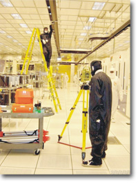
Precision Layout in a Controlled Environment
 PMI uses the industries most precise survey instruments to direct the placement of semiconductor producing systems. This machinery (tools) must be set to exact specifications due to the use of overhead automated delivery systems that transfers products throughout the different manufacturing areas.
Tolerances
Allowable tolerances for overhead automated delivery systems interaction with a tool’s Load Port is approximately +/- 5 mm
Advantages of Using PMI
 PMI’s specialized teams have the ability to work hand in hand with everyone involved with the placement of the tools from designers and engineers to millwrights and tool vendors.
- Customers can rest assured that each multi-million dollar “tool” is in the proper location, having to relocate a tool is “time and money” and some tools cannot be relocated after installation.
- While our survey personnel are on-site, we are able to provide other services that may arise. An example of this may be to provide typical construction staking outside of the clean room for items that may arise from the base build.
- Areas of concern within the clean room environment may be to align a part horizontally and vertically inside a tool in order for the tool owner to complete work on a damaged tool.
Deliverables
- PMI can provide the customer with exact coordinates of the location of each tool that has been installed in hard copy form or in a digital format.
- At each stage of tool setting our experienced survey team is there on location to give instructions as placement of the tool.
- Through experience, PMI has found that an initial set needs to be followed up with a final location due to movement at the tool is assembled.
Hydrographic Surveys

PMI has the ability to offer full service Hydrographic Surveying services utilizing fully digital equipment.
PMI has four hydrographic vessels to perform its surveys. For large bodies of water, a 23’ semi-enclosed boat as well as a 21′ fully-enclosed aluminum survey vessel. The other two are smaller, open skiffs. This allows PMI the versatility to perform surveys in shallow water. In addition to the vessels listed above, PMI also utilizes a proprietary designed robotic vessel, incorporating a single beam echo-sounder and RTK GPS system, for accessing extremely shallow areas.
On-board these vessels PMI utilizes a range of navigation systems to provide extremely accurate horizontal and vertical data. PMI utilizes Odom and R2Sonic System depth sounding equipment in conjunction with RTK GPS.
PMI holds multiple Annual Service Contracts from various Districts of the Army Corps of Engineers. As such, PMI follows the operational procedures outlined in the Corps of Engineers Hydrographic Survey Manual. PMI also follows the procedures outlined in the Corps Manual for its quality assurance program.
The secret to PMI’s success in providing a quality product in a timely manner is our unique process of hand picking key personnel that have expe rience, education, and professionalism to make them leaders in their respective fields.
PMI prides itself on its highly trained, versatile work force. Our technicians are fully trained and experienced in all aspects of the surveying industry, from cadastral to geodetic surveys.
PMI’s philosophy of utilizing the latest in technological advances coupled with our particular attention to details enables us to maintain control over expenses and direct labor costs. PMI’s commitment to digital data collection and in-house GPS capabilities, gives us the capabilities to perform surveys with fewer personnel and less man-hours.